
REGENCY RAMSGATE
Walk 2
RAMSGATE DURING THE REIGN OF THE FUTURE GEORGE IV AS PRINCE REGENT
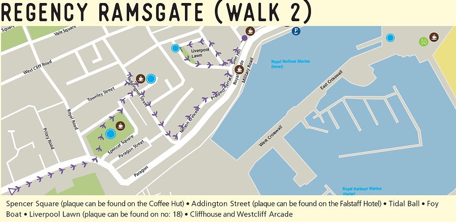
Ramsgate has many squares and crescents from the Regency Period. Walk 2 takes you through a selection of these.

SPENCER SQUARE
As you walk along the road past St. Augustine’s and then Regency School of English, you will see tennis courts to the left. Cross the road, when clear, and you will be at Spencer Square.
Opposite the tennis courts is Royal Road, Vincent van Gogh taught at Number 6 for six months in 1876.
Initially the site of a parade ground for troops readying for deployment to fight Napoleon in the early 1800s, the square was large enough to hold both foot and mounted soldiers at the same time. It is likely the ground stretched at least as far as back of the current houses, if not farther.
The houses making up Spencer Square today are all Grade II listed and have housed many notable people, particularly van Gogh who lived at number 11 in 1876 and John Gibson Lockhart, son-in-law of Sir William Scott, lived in number 4.
In the middle of the square are Spencer Gardens, the tennis courts, and the coffee hut.
With the coffee hut to your right, walk to the far-left corner of Spencer Square, then walk along Spencer Street. On the right are a few old cottages, along Spencer Place; one of which has original fixtures on its walls.
At the end of this short road is Addington Street. To see the entire street, first walk to the left and then back up, past Spencer Street and continue to the end. See the next page for more on Addington Street.

ADDINGTON STREET
Entering the road from Spencer Street, you are now stood in the centre of what was once the High Street for the West Cliff. During the 1800s, Addington Street was filled with garrison buildings and mess halls, some of which survive today as houses. With the influx of the well-to-do after the Napoleonic Wars, the street became a shopping centre, catering to all needs.
The Falstaff Inn, to the left as you came to the street, was created in c.1840s from two smaller houses, later another house was added which is now the kitchen area. It was recently refurbished, incorporating original features with modern design.
Addington Street suffered heavily during both World Wars. Many Zeppelin and blitz raids resulted in the loss of large portions of the street and the deaths of many residents. During one of the many air raids, on the 20th March 1941, numbers 63 and 69 both received direct hits and were destroyed. They were among 12 buildings in the area to be demolished in this raid. George Crompton and Bernard Woodfield both died in this raid, survived by their wives. If you walk towards the sea, you will notice a series of new houses on either side of the road, built in-keeping with the rest. A reminder of what was lost during the wars.
Some of the information used in this booklet has come from Thanet at War 1939-1945 by Roy Humphries (1991). A very good book with detailed lists of raids, bombings, lost houses, and deaths throughout the war. An interesting survival tip for air raids seems to have been to go shopping, as many people survived air raids while at the shops.
There is an annual Addington Street Revival Fair every September. A fair celebrating everything Addington Street has to offer, while displaying its history and heritage.
It has also been, and still is, the site of many street parties – from the relief of Mafeking during the Second Boer War, the end of World War Two, and Queen Elizabeth II’s coronation.

NELSON CRESCENT
Turn left as you leave Addington Street at the sea end. Built in the early 1800s, the houses of Nelson Crescent, like
Wellington Crescent on the East Cliff, have fine Chinese Pagoda-style canopied balconies and intricately designed ironwork railings and supports. The novelist Wilkie Collins stayed at number 14 in the 1870s and Alfred Luck lived at number 11.

TIDAL BALL
Walking from Nelson Crescent to Sion Place, you will see the tidal ball. It was in operation until relatively recently and would have been used by sailors to determine high and low tides, based on the ball’s position on the staff representing a time
of day. There is speculation that the site of the tidal ball may have been a gun emplacement during war-time.

THE FOY BOAT
A former Tomson & Wotton House, this building has a unique name and is on a prime site overlooking the Royal Harbour. It is thought to have evolved from an old watch house dating from the early 18th century, during the Napoleonic Wars. It had a good vantage point on the cliff next to a flagstaff (now the tidal ball). The old tavern was damaged by enemy bombs in 1941, killing the Landlady (the photo above shows the destruction). It was completely rebuilt as one of Ramsgate’s few Mackeson tied houses. The name comes from the foy boats, which serviced the vessels anchored in the downs as they waited to enter the harbour. They also doubled as lifeboats in pre-R.N.L.I. days. Walk past the Foy Boat, keeping it to your right, through to Liverpool Lawn.

LIVERPOOL LAWN
As you walk into Liverpool Lawn from Sion Place, look up and left, you will see the crest of the Earl of Liverpool above Numbers 10 & 11. Walk to the right of the street, along a narrow road devoid of cars and canopied by the trees in the lawn. The buildings here are all Grade II listed, due to their architectural interest and design.
Built between 1827-1840 in the Regency style, Liverpool Terrace (the side with the sweeping terraced houses) and Liverpool Place (the pedestrian side) joined to become Liverpool Lawn in 1867. The area was named after Robert Jenkinson, Second Earl of Liverpool. He was Prime Minister from 1812-1827. He is currently the third longest serving Prime Minister, having served in office for 14 years 305 days.
As you come to the end of this section of Liverpool Lawn, look right and you can see Adelaide Gardens with a blue plaque above the house, opposite, for Sir William Jordan. If you look left, back along Liverpool Lawn, you will see one of the Ramsgate Military & Heritage Trail plaques, above the door of Number 18. Walk towards it and then turn left.
During the Second World War, the lawn in the centre had its iron railings removed for the war effort (as happened in many places across Ramsgate and the country), the remains can still be seen along the edge of the lawn.
Leading up to the war, Liverpool Lawn was chosen as one of the locations for an entrance to the newly constructed Ramsgate Tunnels. Although sealed and covered by grass, you can still see the outline during dry periods, when the grass above browns.
For other Regency style buildings, see Paragon (West Cliff Return walk) and Wellington Crescent (East Cliff walk).
Walking back to Sion Place, keep the harbour to your right and walk down the short flight of stairs, onto West Cliff Arcade.

CLIFF HOUSE AND WEST CLIFF ARCADE
Going back to the days when Ramsgate harbour became royal, there was a great house that played a very important part in this great honour. Cliff House was a very attractive mansion situated on the rise to the West Cliff and the grounds were extensive, covering the site of the multi-storey carpark and up to Rose Hill.
This was the home of Sir William Curtis Bart whom was a great friend of King George IV. Sir William was also known as ‘Billy Biscuit’ as he owned the biscuit factory which supplied the Royal Navy. This friendship included several visits by His Majesty to Cliff House in 1821 when he stayed in Ramsgate on his journeys to and from Hanover. These visits and the amazing reception His Majesty received from the people of Ramsgate convinced him to bestow the title ‘Royal’ onto the harbour; it is the only Royal Harbour in the United Kingdom.
The building was later used as the site of the local Law Courts and a Mother Care Clinic. As mentioned, the site was completely demolished and is now the Multi-Storey Car Park and the site of the Royal Temple Yacht Club.
As you walk past the current Cliff House, with its own blue plaque to Sir William Curtis, keep it on your left and the harbour to your right, walk down the stairs and you will find West Cliff Arcade, a quaint alley filled with restaurants overlooking the harbour. A great place for lunch or a quick rest-stop. Alternatively, avoiding the stairs, turn back and walk along Nelson Crescent, keeping left, then walk down Royal Parade, turn left and left again to reach West Cliff Arcade.
From here, turn left onto Leopold Street, walking until you turn the corner and Effingham Street is to the right, bracketed by estate agents.